Ferry Reach, Bermuda
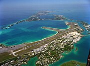
Channel in the north-east of BermudaFerry Reach is a three mile long channel in the north-east of Bermuda, which lies between St. George's Island in the north and St. David's Island in the south, south-west of the town of St. George's.
Read article


Top Questions
AI generatedMore questions
Nearby Places
Kindley Air Force Base
Former United States Air Force base in Bermuda

The Causeway, Bermuda
Narrow strip of reclaimed land and bridges in the north of Bermuda

Coney Island, Bermuda
Island in Bermuda
St. David's Island, Bermuda
One of the principal islands of Bermuda
USCG Air Station Bermuda
Former US Coast Guard base in Bermuda

Bermuda Railway
Railway line in Bermuda

Bermuda Institute of Ocean Sciences
Non-profit marine science institute
Rogue Island, Bermuda